rocscience Software
Rocscience RSLog
Web-based Borehole Log Management

Features in RSLog
Technical Specifications
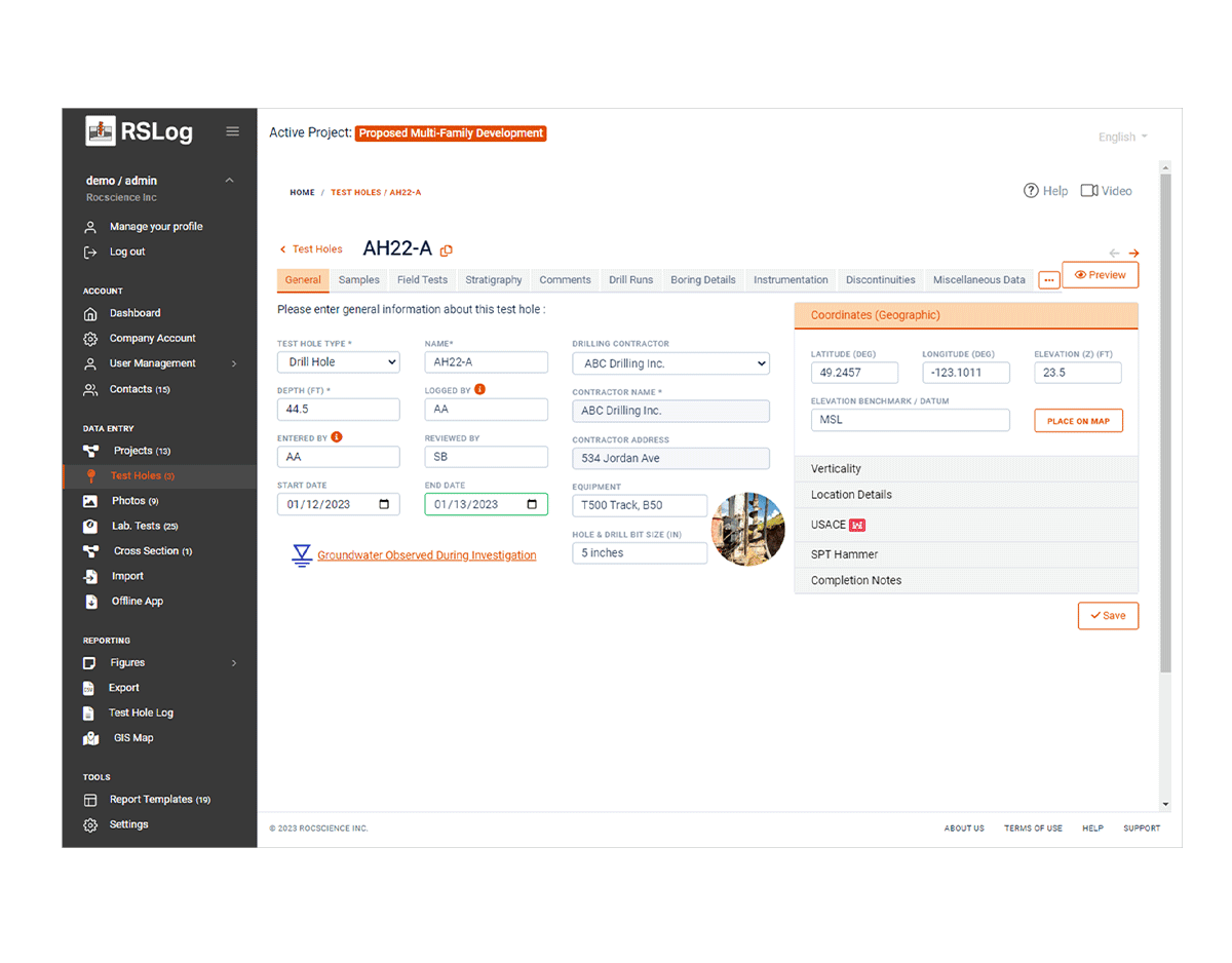
Borehole Data Entry
- General Borehole Data (e.g. title, depth, water level, verticality, etc)
- SPT Hammer Details
- Groundwater Monitoring
- Coordinates
- Samples
- Field Tests (SPT, Pocket Pen, DCP, CPT, etc)
- Comments and Observations
- Stratigraphy Data (lithologic description of layers)
- Boring details
- Drill Runs
- Discontinuities
- Piezometer / Well Installation
- Laboratory Test Results (for each sample)
- Project Photos
Customizable Lists
- List of Sample Types
- List of Field Tests
- List of Laboratory Tests
- List of Drilling Methods
- List of Piezometer/Well Types
- All Rock Classifications (e.g. strength, weathering, alteration, slaking, defect types etc)
Major Features
- Role-Based User Management (permissions and access levels)
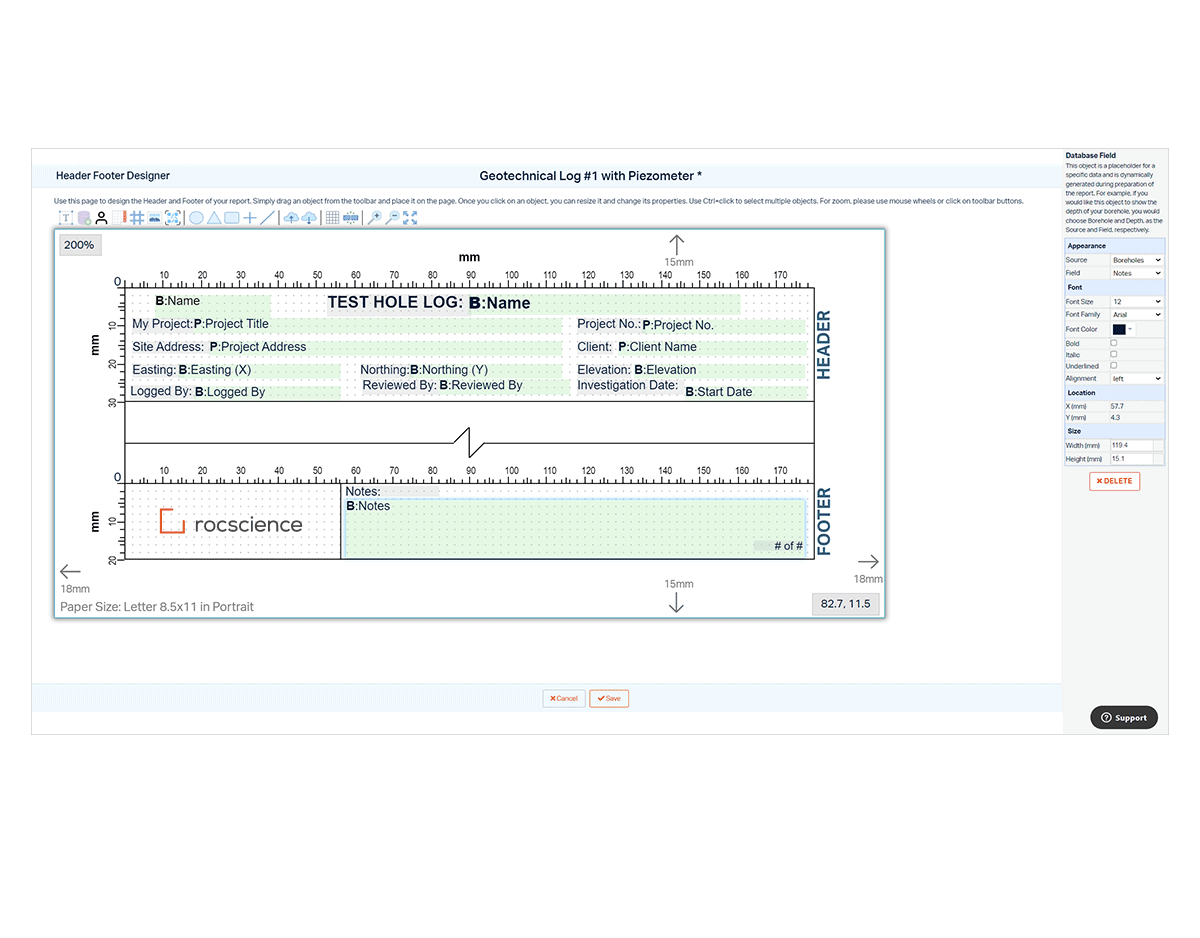
- Borehole Log Preparation
- Log Template Design
- Cross Section Design (2D / 3D)
- Report Figures (for project location map and boreholes location maps)
- Photo Report
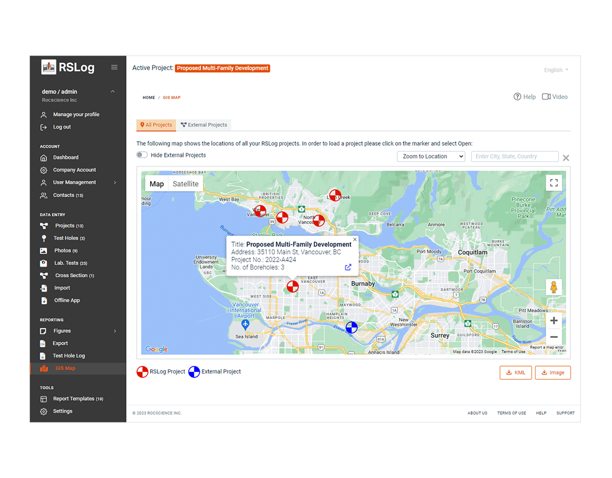
- GIS Map
- Offline App
- Import / Export
Supported Coordinate Systems
- WGS84 (geographical)
- UTM
- Local datum
Hatch Patterns
- USCS
- AGS
- Rock
- Miscellaneous
Data Import Formats
- Excel, CSV
- gINT
- DIGGS
- AGS
Data Export Formats
- Excel, CSV
- JSON
- DXF
- KMZ
Data Access Options
- Online via Internet Login (anywhere and anytime)
- Offline:
- via RSLog Offline App
- via RSLog Excel Templates
RSLog across Applications
Once your data is in RSLog, any project or borehole related data such as lithologic descriptions, samples, field/laboratory tests results and piezometer/well installation can be presented on the borehole log. Other users in your RSLog account can collaborate by reviewing the draft borehole logs, add comments, and approving the logs.
Streamline the process of collecting and transferring data from the field or at the office using any device, with RSLog’s web-based functionality, it’s offline app, and powerful integrations with other applications programs (Slide2, Settle3, gINT, DIGGS, Excel). RSLog also gives you the option to integrate laboratory test results and present them in your borehole logs.
Using the cross-section designer, turn borehole data into cross-sections and visualize subsurface conditions, without the need for other CAD or drafting tools. Connect the layers, apply hatch patterns, indicate underground utilities, show contaminated zones, and view your project cross sections in 3D. Include a topographic terrain model, and export your cross section to various formats (PNG, SVG, DXF, KMZ, etc).
Explore the latest features in RSLog
DIGGS (Data Interchange for Geotechnical and Geo-environmental Specialists) is a standard international format for the electronic transfer of geotechnical and geo-environmental data. If your project data is saved in a DIGGS file, use RSLog to import relevant sections of your DIGGS file and generate borehole logs and other types of reports.
Save your time with RSLog and create a photo report by one click. All your project photos will be inserted in a photo album downloaded in PDF format. You can select which photos should be included in the report, add a title for each photo and select how many photos will be inserted on each page.
Import your important geotechnical investigation data from gINT to RSLog as a new project and easily refer to them whenever you need them. This way you can conveniently organize all your gINT project files in one place.
Rocscience Products
Rocscience RSPile
rocscience SoftwareRocscience RSPile 3D Pile Analysis Lateral & Axial Pile Analysis Carry out lateral & axial analyses of various piles with the flexibility to design piles with multiple sections and model complex soil strata using boreholes. Capacity Pile...
Rocscience Settle3
rocscience SoftwareRocscience Settle3 Soil Settlement and Consolidation Analysis Settlement Analysis Perform soil settlement analysis to analyze immediate settlement, primary consolidation and secondary settlement of embankments, foundations, and surface loads. Easily...
Rocscience CPillar
rocscience SoftwareRocscience CPillar Support Estimation Using Ground Reaction Curves Crown Pillar Stability Analysis Get quick and easy stability analysis of surface or underground crown pillars and laminated roof beds using three different limit equilibrium analysis...
Rocscience RocSupport
rocscience SoftwareRocscience RocSupport Support Estimation Using Ground Reaction Curves Ground Reaction Curve Easy-to-use software for estimating deformation of circular excavations in weak rock. Given the tunnel radius, in-situ stress conditions, rock parameters and...
Rocscience UnWedge
rocscience SoftwareRocscience UnWedge Underground Wedge Stability Analysis Underground Wedge Stability Analysis Analyze underground tunnel excavations with intersecting discontinuities and visualize the model in 3D. Determine the stability of tetrahedral wedges formed...
Rocscience EX3
rocscience SoftwareRocscience EX3 3D Stress Analysis for Underground Excavations Boundary Element Method & Stress Analysis Perform faster analysis of underground excavations using Boundary Element Method, which only requires meshing of the surface, resulting in...
Rocscience RocTopple
rocscience SoftwareRocscience RocTopple Toppling Stability Analysis for SlopesBlock Toppling Model Analyze 2D block or block-flexural toppling stability given the slope geometry, and the joint spacing, dip and strength. RocTopple employs the Block toppling method of...
Rocscience RocPlane
rocscience SoftwareRocscience RocPlane Graphical and Statistical Analysis of Orientation DataPlanar Rock Slope Analysis Quickly and easily define planar wedge models, visualized in 2D and 3D. Perform planar sliding stability analysis using Limit Equilibrium Method....
Rocscience Dips
rocscience SoftwareRocscience Dips Graphical and Statistical Analysis of Orientation DataStereographic Projection Analysis Designed for interactive analysis of orientation based geological data. Visualize orientation vectors, density contours, planes, intersections,...
Rocscience RSData
rocscience SoftwareRocscience RSData Strength & Stress Analysis of Rock and Soil MaterialsVirtual Soil Mechanics Lab Utilize constitutive models like NorSand and Modified Cam Clay to get an in-depth look into the stress-strain relationship of your soil materials....
Rocscience RocSlope
rocscience SoftwareRocscience RocSlope 3D Block Stability Risk Assessment for Rock SlopesModel 3D Geological Structures For 3D slope geometries of benches, highway cuts, and entire open pits, model structurally controlled failure in rock slopes exhibiting jointing...
Rocscience RocFall3
Rocscience Software rocscience SoftwareRocscience RocFall3 3D Assessment of Slopes at Risk for Rockfalls3D Model Creation Constructing rockfall models is easier and faster than ever. Import ground surfaces from geological modelling or mine planning software or with...
All Products
Ansys Granta Selector
Ansys SoftwareAnsys Granta Selector Smarter Materials Choices Ansys Granta Selector materials selection software lets you innovate, resolve materials issues, reduce costs and validate your materials choices. Select the best materials for your application and then...
Ansys Additive Print
Ansys SoftwareAnsys Additive Print Predict Stress & Distortion in the AM Process Build parts right the first time with Additive Print. Users can check for distortion, stress and strain regions, predict blade crash and export to Ansys Workbench Additive for...
Ansys Additive Suite
Ansys SoftwareAnsys Additive Suite Comprehensive Additive Manufacturing Solution With Ansys Additive Suite, users have access to all Additive tools, including Additive Prep, Additive Print, Additive Science and Workbench Additive.A comprehensive solution for designs,...
Ansys Thermal Desktop
Ansys SoftwareAnsys Thermal Desktop Heat Transfer & Fluid Flow Modeling Software From comprehensive two-phase flow capabilities to advanced finite element analysis, our world-class software is a critical tool for any thermal or fluids engineer. Ansys Thermal...
Ansys LS-DYNA
Ansys SoftwareAnsys LS-DYNA Multiphysics Solver Ansys LS-DYNA is the industry-leading explicit simulation software used for applications like drop tests, impact and penetration, smashes and crashes, occupant safety, and more. LS-DYNA delivers a diverse array of...
gINT
virtuosity bentley Software gINTImprove subsurface data management productivity Bentley’s gINT software provides you with centralized data management and reporting for a wide variety of geotechnical subsurface projects. gINT software helps you eliminate repetitive...
Ansys Discovery
Ansys SoftwareAnsys Discovery Rapid Design Exploration Ansys Discovery features the first simulation-driven design tool combining instant physics simulation, high-fidelity simulation and interactive geometry modeling in a single easy-to-use experience. Ansys Discovery...
Ansys SpaceClaim
Ansys SoftwareAnsys SpaceClaim 3D Modeling Software SpaceClaim now included in Discovery Modeling license SpaceClaim offers lightweight 3D modeling for fast, simple answers Ansys SpaceClaim is the perfect modeling solution for engineers who want access to 3D answers...
Ansys EnSight
Ansys SoftwareAnsys EnSight Simulation Data Visualization Software Analyze, visualize and communicate your simulation data with Ansys EnSight. A general-purpose post processing software allowing you to gain insights and understandings from your simulations. EnSight...
Ansys Polyflow
Ansys SoftwareAnsys Polyflow Polymer Processing Simulation Software Ansys Polyflow is a finite-element based CFD software used to reduce the cost of polymer, glass, metals and cement processing. Accurately Assess Viscoelastic Fluids Ansys Polyflow accelerates design...
Ansys Forte
Ansys SoftwareAnsys Forte Compressor and Engine Simulation Software Ansys Forte is a computational fluid dynamics software for modeling internal combustion engines and positive displacement compressors. Accurately and efficiently model your engine or compressor with...
Ansys Chemkin-Pro
Ansys SoftwareAnsys Chemkin-Pro Chemistry Simulation Software Ansys Chemkin-Pro is the industry leader for modeling complex, chemically reacting systems. It has been extensively validated in numerous chemistry applications and is well known for its extremely fast...

